Main Information
LCI: jpn1607131407
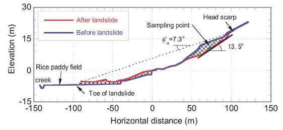
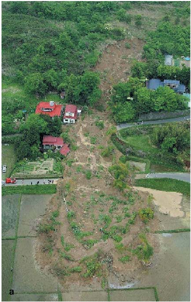
An earthquake with a moment magnitude of 7.0 occurred in northern Japan on May 26, 2003. Landslides were triggered by the earthquake, and among which a massive landslide occurred in the Tsukidate area, northwest of Sendai, the capital city of Miyagi Prefecture. The Tsukidate landslide partially destroyed two houses. Although two people were partially buried by the displaced landslide mass, both were subsequently rescued. The landslide was triggered on a gentle slope with the sliding surface inclination of approximately 13.5 degrees. The displaced landslide mass traveled a long distance of about 130 m, and finally spread and deposited on a horizontal rice paddy, thus showing some typical characteristics of rapid long traveling flow phenomenon. Because this landslide was triggered by an earthquake without rainfall, the fluidization behavior of the landslide attracted the attention of researchers in various fields.
Location
City / District: Tsukidate
Province: Miyagi
Country: Japan
Latitude: 38:44:59 N
Longitude: 141:00:51 E
Reporter
Reporter 1: Khang Dang
Reporter 2: Hiroshi Fukuoka
Landslide Type
Material: Earth
Movement: Slide
Velocity (mm/sec): Rapid (5×10⁻¹ - 5×10¹ )
Depth (m): Moderate-Shallow (5 - 20)
Slope (degree): Gentle (10 - 20)
Volume (m³): Unknown
Date of Occurence
Date of Occurence: 05/26/2003
Other Information
Land use (Source Area): Forest
Land use (Run-out/deposition area): Farming, Human settlement
Other Activity: Active in the past
Triggering Factor: Earthquake
Death(s) & Missing: -
Houses and other structural damage: 2 houses
Photo of landslide
Google earth kmz file
Plan of landslide
Cross section of landslide