Main Information
LCI: JPN1607070918
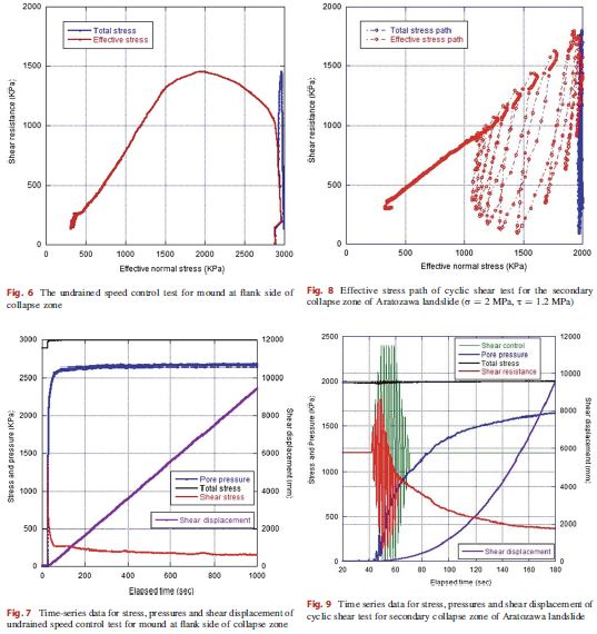
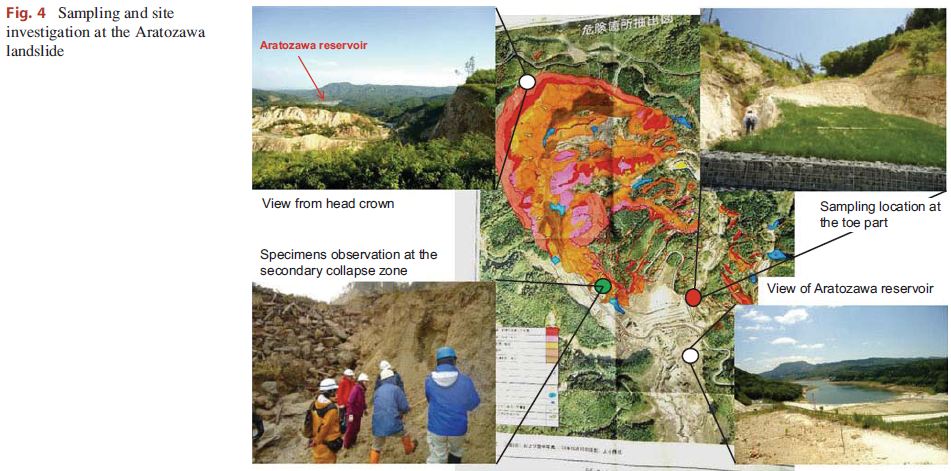
A huge landslide, namely Aratozawa, was triggered by the Miyagi-Iwate inland earthquake with magnitude 7.2 on 14 June 2008. This translational block glide of deep and large-scale landslide occurred at an upstream section of Aratozawa Dam in Kurihara city, Miyagi Prefecture, Japan. The catchment area of the Aratozawa is around 20.4 km2 and the designed water storage capacity is approximately 14,130 thousand m3.The size of the Aratozawa landslide is around 1300 meters long and 900 meters wide. The thickness of the landslide ranges from 70 meters to 150 meters and the gradient is about 3°. This landslide seems to be the biggest landslide occurring in Japan in the last 100 years. The total volume of the landslide was assessed to be around 67 million cubic meters. By using 3.0 MPa undrained dynamic loading ring shear apparatus ICL2 to analyze the mechanism of the landslide, the effect of groundwater fluctuation and the inter-linkage with the reservoir in the Aratozawa dam was found to be the main causes in addition to the peak ground acceleration of more than 1,000 gal. This report referred the research in the paper: Hendy Setiawan, Kyoji Sassa, Kaoru Takara, Toyohiko Miyagi, Hiroshi Fukuoka, and Bin He (2014). The simulation of a deep large-scale landslide near Aratozawa dam using a 3.0 MPa undrained dynamic loading ring shear apparatus. World Landslide Forum 3, at Beijing, China
Location
City / District: Kurihara
Province: Miyagi
Country: Japan
Latitude: 38:53:40 N
Longitude: 140:51:43 E
Reporter
Reporter 1: Ha Nguyen Duc
Reporter 2: Hendy Setiawan
Landslide Type
Material: Complex
Movement: Slide
-
Depth (m): Very Deep (100 - 500)
Slope (degree): Almost flat (5 or less)
Volume (m³): Very Large (10⁷-10⁸)
Date of Occurence
Date of Occurence: 06/14/2011
Other Information
Land use (Source Area): Forest
Land use (Run-out/deposition area): Forest, Sea/lake
-
Triggering Factor: Earthquake
-
Photo of landslide
Google earth kmz file
Plan of landslide
Cross section of landslide
Reference (paper / report) (Insert link)
Testing graph