Takanodai Landslide
LCI : JPN1609161455| Main Information | |
| Landslide Name | : Takanodai Landslide |
| Latitude | : 32:53:4.66 N |
| Longitude | : 131:0:15.14 E |
| Location | |
| City / District | : Kawayo |
| Province | : Kumamoto |
| Country | : Japan |
| Reporter | |
| Reporter 1 | : Khang Dang |
| Reporter 2 | : Kyoji Sassa |
| Landslide Type | |
| Material | : Earth |
| Movement | : Slide |
| Velocity (mm/sec) | : Extremely Rapid |
| Depth (m) | : Moderate-Shallow |
| Slope (degree) | : Gentle |
| Volume (m³) | : Large-Moderate |
| Date of Occurence | |
| Date of Occurence | : Apr 16, 2016 |
| Other Information | |
| Land Use |
Source area : - Run-out/deposition area : Road |
| Other Activity | : Active in the past |
| Triggering Factor | : Earthquake |
| Death(s) & Missing | : 5 |
| Houses and other structural damage | : 7 |
| Photo of landslide | : 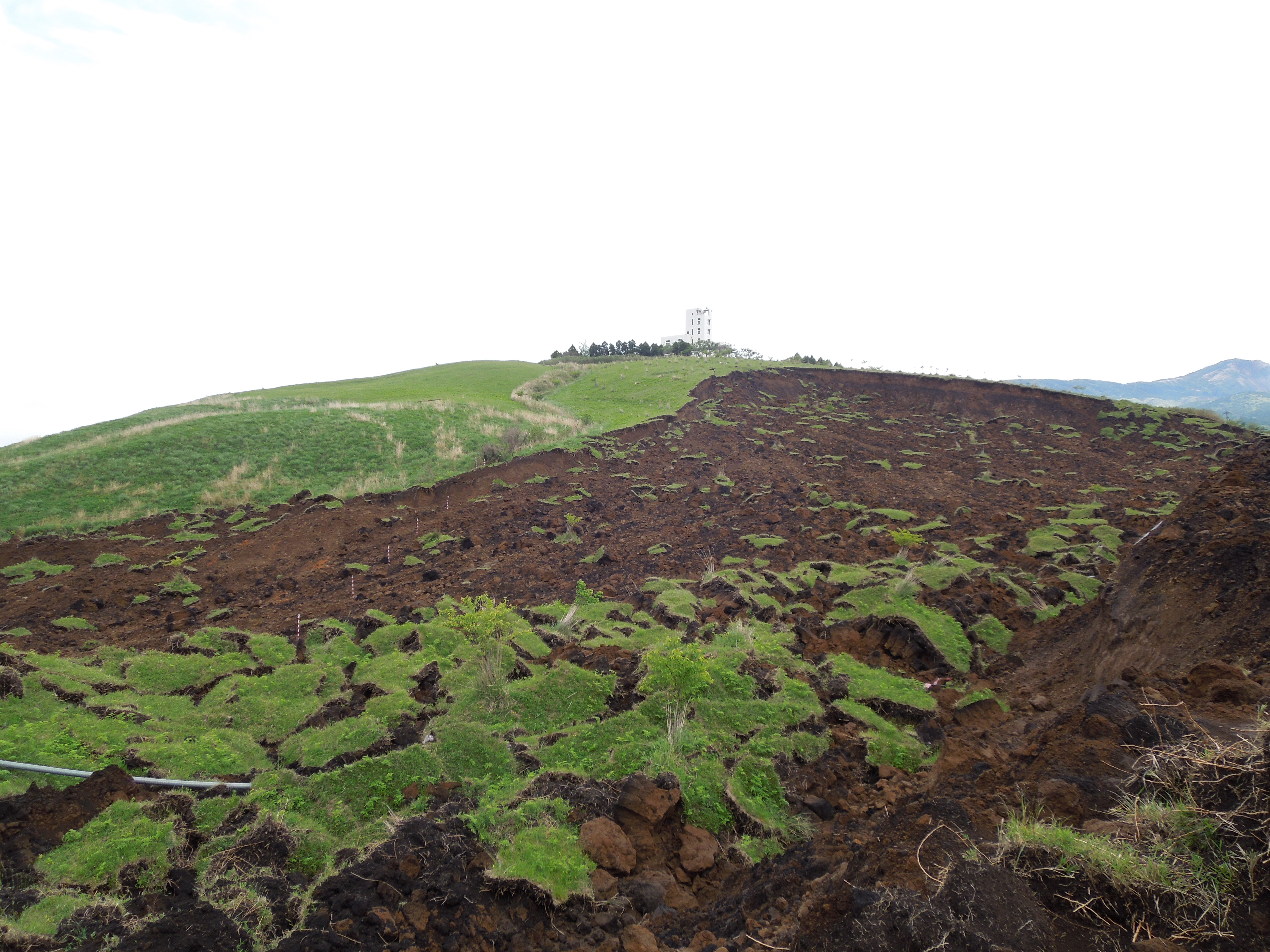 |
| Google earth kmz file | : Takanodai Landslide.kmz |
| Plan of landslide | : 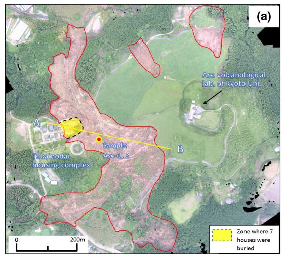 |
| Cross section of landslide | : 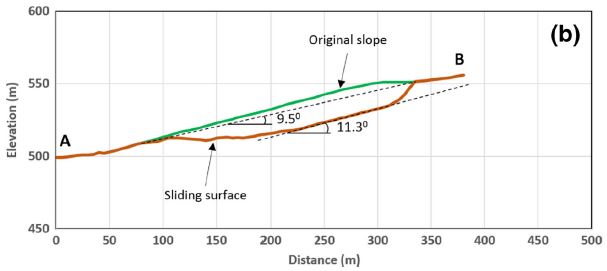 |
| Reference (paper/report) | : http://link.springer.com/article/10.1007/s10346-016-0748-9 |
| Testing graph | : Kumamoto Testing Data with graph-Seismic1478770424.xlsx |
| Monitoring graph | : Kumamoto Earthquake Graph-Final1478770425.xlsx |
| Video of moving landslides including 3D simulation | : https://youtu.be/dNovx0VvWas |
| Description | : |
The 2016 Kumamoto earthquakes were a series of earthquakes, including two main shocks which occurred beneath Kumamoto City, Kumamoto Prefecture, Kyushu Region, Japan. A M6.5 earthquake occurred at 21:26 JST on April 14, and a M7.3 earthquake struck at 01:25 JST on April 16 (National Research Institute for Earth Science and Disaster Resilience, NIED). The two earthquakes killed at least 49 people and injured about 3000 others. More than 44,000 people were evacuated from their homes due to the disaster. These two events generated most of the building damage and many of the landslides in the Kumamoto area. According to Japan’s Ministry of Land, Infrastructure, Transport and Tourism, at least 97 landslide locations were confirmed in the Aso area. Among these earthquake-triggered landslides, the largest landslides were two very substantial slope failures. One was located on the National Road 57 and destroyed an important bridge. The other occurred near the Aso volcanological laboratory of Kyoto University and destroyed seven houses. The Takanodai landslide includes three landslide blocks on the hillslope below the Aso volcanological laboratory of Kyoto University in Minamiaso village, Kumamoto Prefecture. The largest one destroyed seven houses of the Takanodai housing complex and killed five people (Ministry of land, infrastructure, transport and tourism). After triggering by earthquake, this landslide moved at least 150 m. – – – – – Source: Dang, K., Sassa, K., Fukuoka, H. et al. “Mechanism of two rapid and long-runout landslides in the 16 April 2016 Kumamoto earthquake using a ring-shear apparatus and computer simulation (LS-RAPID)”. Landslides (2016) . doi:10.1007/s10346-016-0748-9 |
|

