Slano Blato Landslide
LCI : SVN201612061910| Main Information | |
| Landslide Name | : Slano Blato Landslide |
| Latitude | : 45:54:0 N |
| Longitude | : 13:51:0 E |
| Location | |
| City / District | : Stomaz |
| Province | : Ajdovscina |
| Country | : Slovenia |
| Reporter | |
| Reporter 1 | : Khang Dang |
| Reporter 2 | : Boštjan Pulko |
| Landslide Type | |
| Material | : Debris, Earth |
| Movement | : Flow |
| Velocity (mm/sec) | : Moderate |
| Depth (m) | : Moderate-Shallow |
| Slope (degree) | : - |
| Volume (m³) | : Large-Moderate |
| Date of Occurence | |
| Date of Occurence | : Mar 28, 1887 |
| Other Information | |
| Land Use |
Source area : Forest Run-out/deposition area : Road |
| Other Activity | : Active in the past |
| Triggering Factor | : Rainfall |
| Death(s) & Missing | : - |
| Houses and other structural damage | : main road |
| Photo of landslide | : 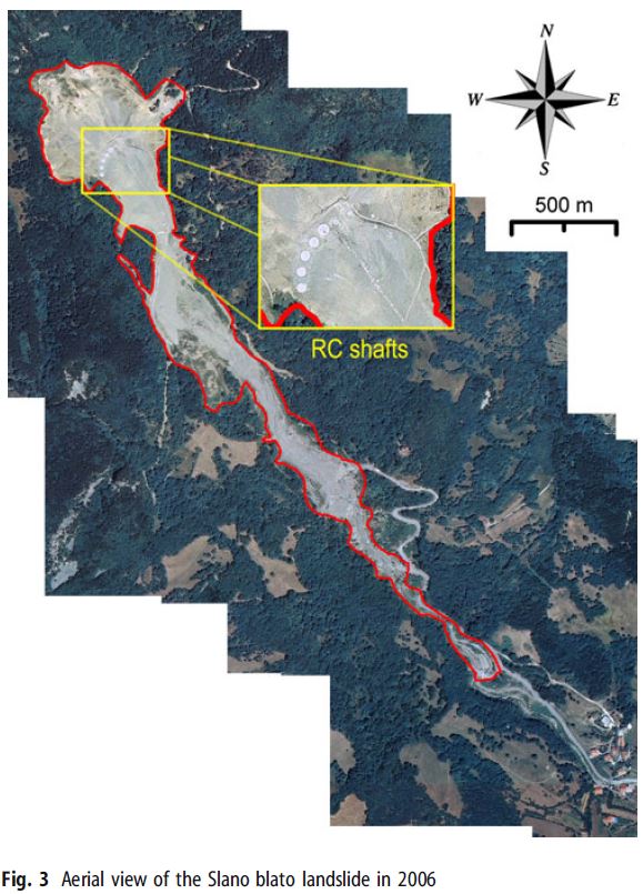 |
| Google earth kmz file | : Slano Blato Landslide.kmz |
| Plan of landslide | : - |
| Cross section of landslide | : 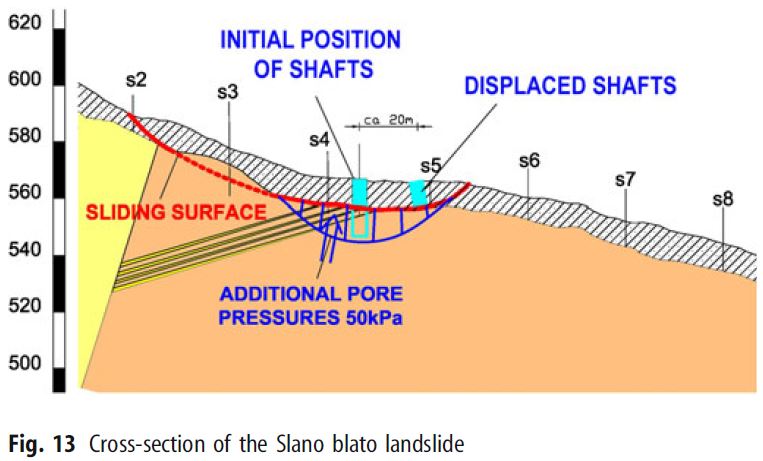 |
| Reference (paper/report) | : http://link.springer.com/article/10.1007/s10346-012-0372-2 |
| Testing graph | : - |
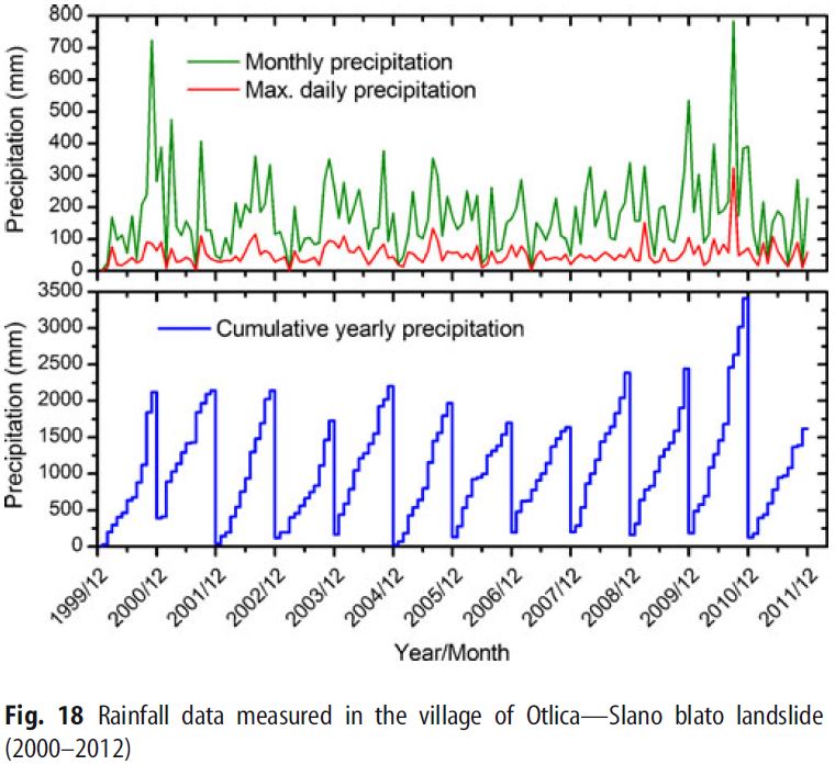
| Monitoring graph | : Rainfall Data-Otlica-Slano blato landslide 2002-2012.JPG |
| Video of moving landslides including 3D simulation | : - |
| Description | : |
Slano blato landslide is located at 45°54? N 13°51? E in the Eocene flysch region of western Slovenia. The landslide was first mentioned in 1887 with the occurrence of an earth flow destroying the main road in the valley about 2 km away. The landslide was thereafter remediated with a series of torrential check dams along the Grajš?ek stream. The landslide remained stable till November 2000, when during heavy rainfall, a large landslide of mud and debris was triggered, moved along the Grajš?ek stream at a speed of up to 100 m/day and threatened the village of Lokavec situated in the valley below. The landslide is about 1,600 m long, 60 to 250 m wide, with a total sliding mass of about 900,000 m3 located between 270 and 650 m asl. In 2001 and 2002, approximately 230,000 m3 of accumulated debris material were removed from the area of a rockfill dam that was built about 300 m above the village as a part of protection measures, followed by surface and subsurface drainage works and a construction of three RC shafts/wells in 2004, with gradual construction of additional eight RC shafts that were completed in 2007. The landslides is long and relatively shallow with variable slope inclination. Source: Pulko, B., Majes, B. & Mikoš, M. Reinforced concrete shafts for the structural mitigation of large deep-seated landslides: an experience from the Macesnik and the Slano blato landslides (Slovenia). Landslides (2014) 11: 81. doi:10.1007/s10346-012-0372-2 |
|

