San Fratello
LCI : ITA1810021245| Main Information | |
| Landslide Name | : San Fratello |
| Latitude | : 38:00:50 N |
| Longitude | : 14:36:15 E |
| Location | |
| City / District | : Messina/San Fratello municipality |
| Province | : Sicily |
| Country | : Italy |
| Reporter | |
| Reporter 1 | : william frodella |
| Reporter 2 | : |
| Landslide Type | |
| Material | : Complex |
| Movement | : Complex |
| Velocity (mm/sec) | : Slow |
| Depth (m) | : Moderate-Shallow |
| Slope (degree) | : Gentle |
| Volume (m³) | : Large |
| Date of Occurence | |
| Date of Occurence | : Feb 14, 2010 |
| Other Information | |
| Land Use |
Source area : Farming, Urban area, Road Run-out/deposition area : Farming, Pasture |
| Other Activity | : Currently active |
| Triggering Factor | : Rainfall |
| Death(s) & Missing | : - |
| Houses and other structural damage | : Intense slope deformation, severe damages to buildings, roadways, and piping system, about 2000 evacuees |
| Photo of landslide | : 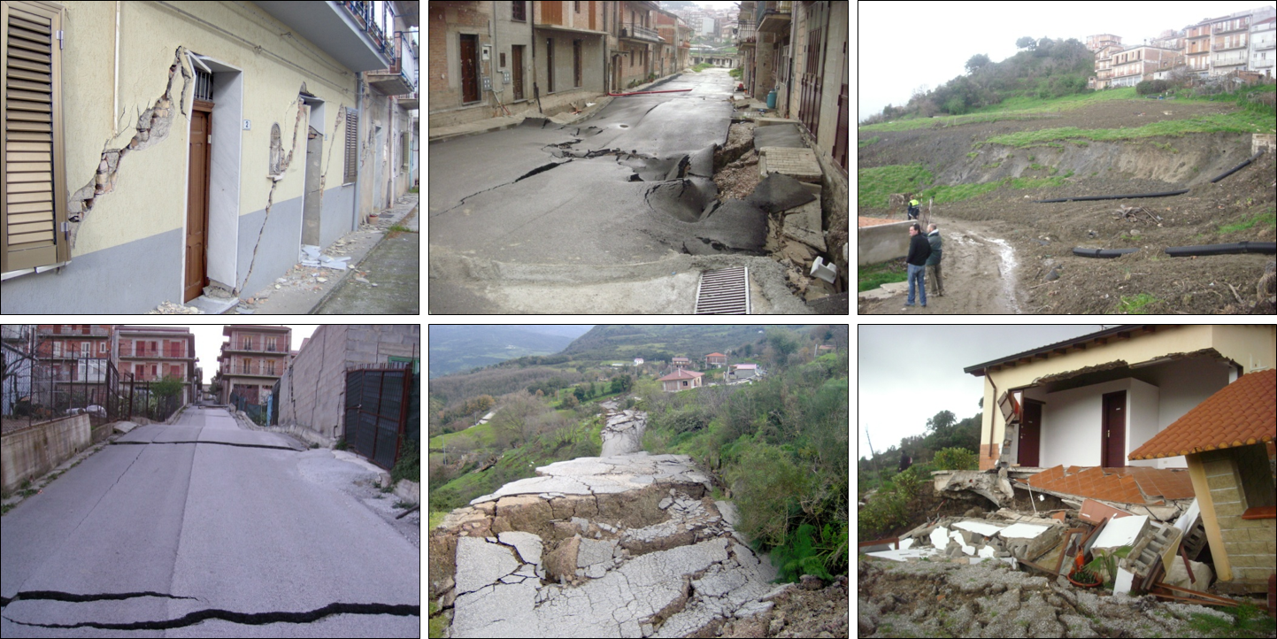 |
| Google earth kmz file | : San Fratello Landslide.kmz |
| Plan of landslide | : 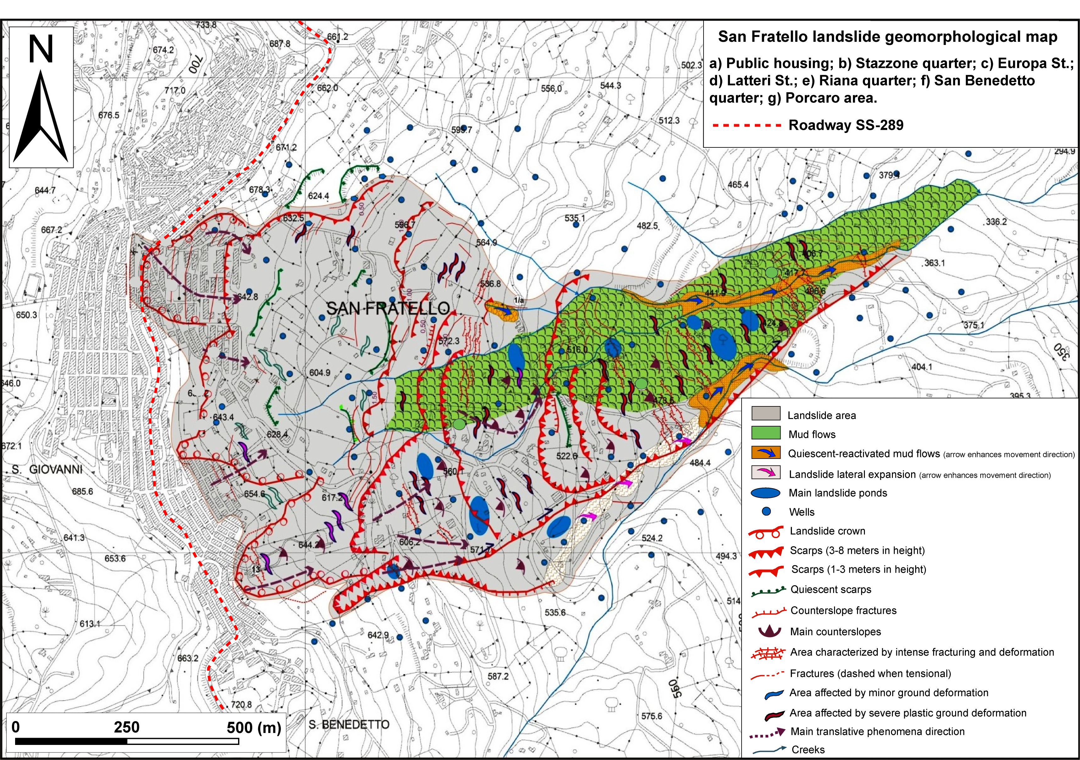 |
| Cross section of landslide | : 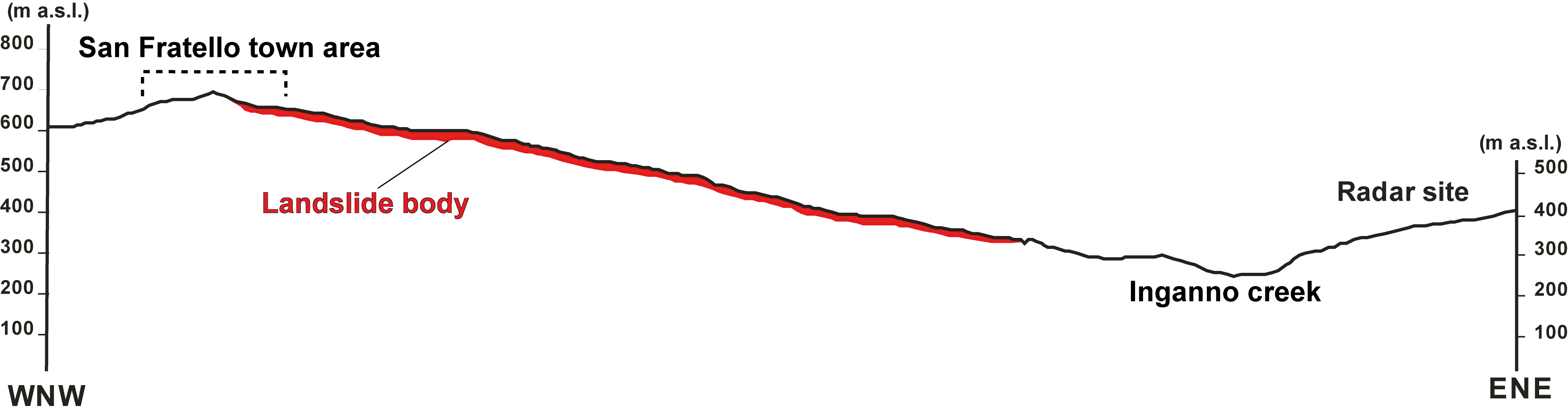 |
| Reference (paper/report) | : Frodella, W., Ciampalini, A., Bardi, F., Salvatici, T., Di Traglia, F., Basile, G., & Casagli, N. (2018). A method for assessing and managing landslide residual hazard in urban areas. Landslides, 15(2), 183-197. https://doi.org/10.1007/s10346-017-0875-y (https://link.springer.com/article/10.1007/s10346-017-0875-y) |
| Testing graph | : Testing graph.tif |
| Monitoring graph | : Control points monitoring graph.tif |
| Video of moving landslides including 3D simulation | : - |
| Description | : |
On February 14th 2010 a large landslide affected the urban centre of the San Fratello town (Sicily Island, Southern Italy), causing severe damages to buildings, roadways and infrastructures, as well as about 2000 evacuees. The landslide affects a 1.2 km2 portion of the Inganno creek Est facing slope, developing for a 450 m level drop with a maximum width of 1.5 km and length of 1.9 km. It can be classified as a complex roto-translational mass movement, about 20 x 106 m3 in size, which involved mainly the silty-clayey cover for an average thickness of 10 m, and only to a lesser extent the bedrock. In topmost sector the phenomenon developed a wide crown area (mainly in correspondence of the town quarter areas), minor scarps and tensional/traction fractures in the middle non-urbanized slope sector, and evolved downstream into a slow earth flow. The resulting ground deformations intensively modified the topographic slope surface, producing multiple scarps (characterized by heights between 5 and 10 m) and counter-slopes, also modifying the hydrographic network with the formation of several landslide ponds. Ground deformations intensively damaged the town structures, in particular: i) the most damaged area was the Stazzone quarter, where prevalent rotational phenomena developed traction fractures in the roadways and compressive fissures on the buildings facades; ii) in the Riana quarter translational sliding phenomena allowed the formation of wide ground traction fractures and sub-parallel fracture systems in the road pavement and secondary scarps; iii) in the San Benedetto and Porcaro quarters, both translational and rotational phenomena and local flows, caused the complete destruction of isolated buildings, roadways, water pipes and the sewer system; iv) in the upper sector of the town a transect of the Cesarò SS 289 roadway, was also severely damaged (https://link.springer.com/article/10.1007/s10346-017-0875-y). |
|

