Randazzo Landslide
LCI : ITA1809251000| Main Information | |
| Landslide Name | : Randazzo Landslide |
| Latitude | : 37:54:00.22 N |
| Longitude | : 14:57:52.15 E |
| Location | |
| City / District | : Randazzo, Catania |
| Province | : Sicliy |
| Country | : Italy |
| Reporter | |
| Reporter 1 | : Simone Mineo |
| Reporter 2 | : Giovanna Pappalardo |
| Landslide Type | |
| Material | : Rock, Debris, Earth |
| Movement | : Complex |
| Velocity (mm/sec) | : Rapid |
| Depth (m) | : Deep-Moderate |
| Slope (degree) | : Moderate |
| Volume (m³) | : Very Large |
| Date of Occurence | |
| Date of Occurence | : Mar 20, 1996 |
| Other Information | |
| Land Use |
Source area : Farming, Pasture, Wildland, Road Run-out/deposition area : Farming, Pasture, Wildland, River |
| Other Activity | : - |
| Triggering Factor | : Rainfall |
| Death(s) & Missing | : - |
| Houses and other structural damage | : Road SS116 and some houses |
| Photo of landslide | : 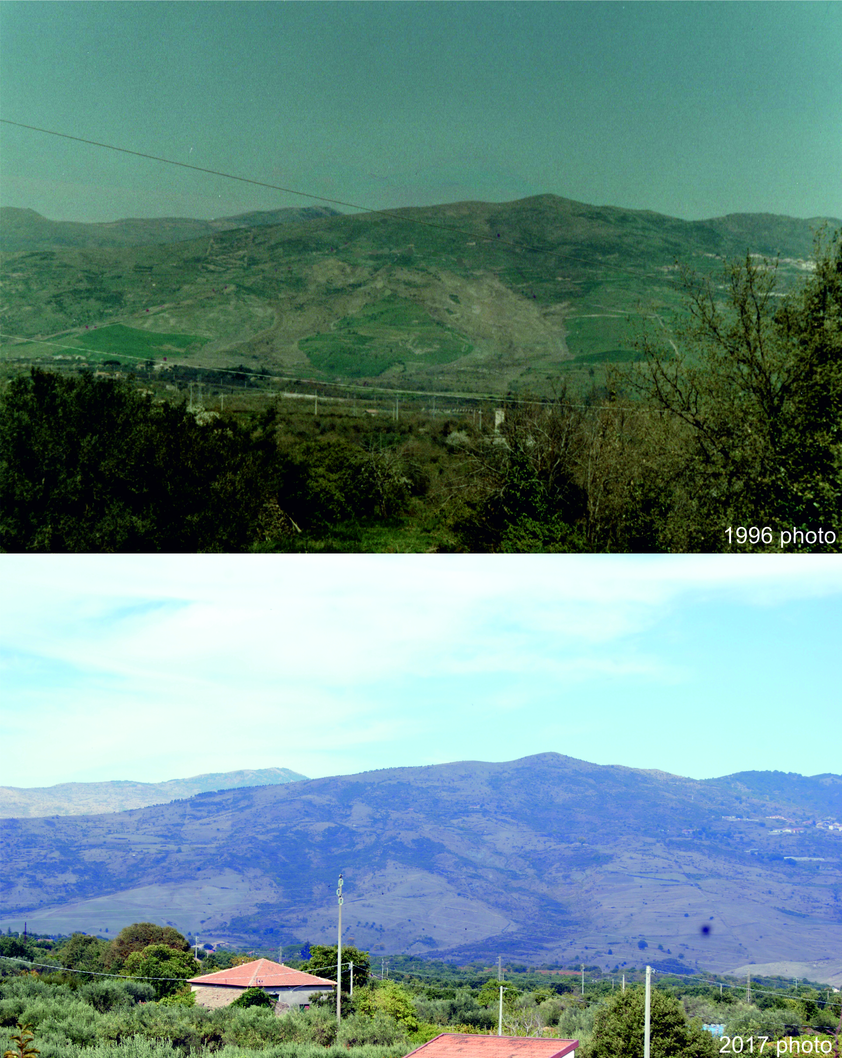 |
| Google earth kmz file | : Randazzo Landslide.kmz |
| Plan of landslide | : 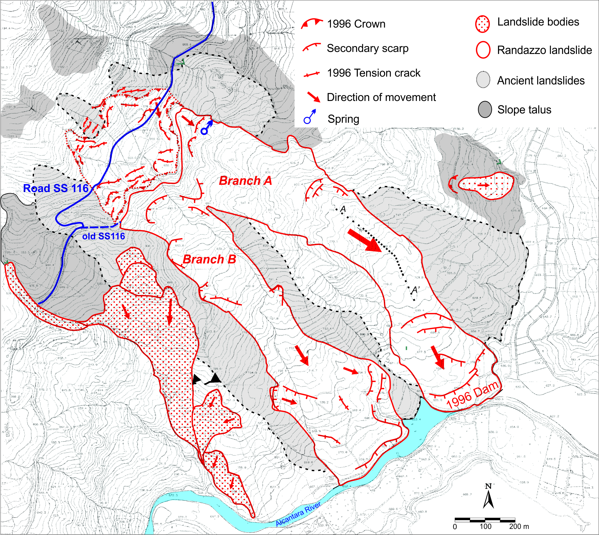 |
| Cross section of landslide | : 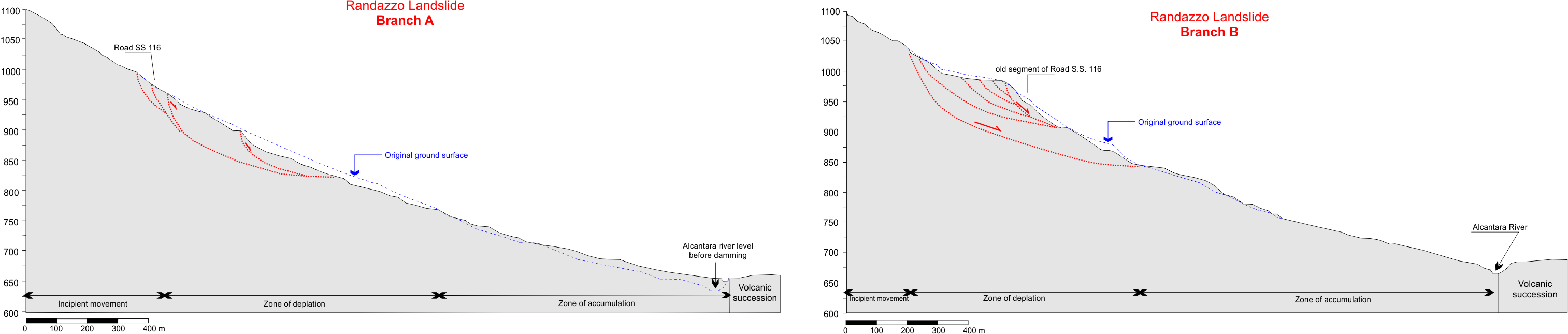 |
| Reference (paper/report) | : Pappalardo G., Mineo S., Angrisani A.C., Di Martire D., Calcaterra D. Combining field data with infrared thermography and DInSAR surveys to evaluate the activity of landslides: the case study of Randazzo Landslide (NE Sicily). Landslides, 2018. DOI 10.1007/s10346-018-1026-9 https://rdcu.be/VcNp |
| Testing graph | : Fig 13.tif |
| Monitoring graph | : Fig 12.tif |
| Video of moving landslides including 3D simulation | : - |
| Description | : |
According to informal interviews to local people, the first movement of Randazzo Landslide (RL) occurred between August and September 1995, after an anomalous rainy month. It consisted in a series of slight rotational motions, which gave rise to a counter slope sector in the middle of the slope, where a new spring fed a small pond. After the following winter, on March 20th 1996, a further movement affected the slope at 900 m of elevation a.s.l. in the form of a rotational sliding (RLa). This movement represents the beginning of an unrelenting landslide, which soon involved the higher portions of the slope in the proximity of SS116. In a few days, the road itself was dislocated downslope by the landslide, while another independent slope movement was triggered south-west of the first landslide (RLb). On March 26th 1996, RLa showed the features of an earth flow, dark in color and visibly saturated with water, which was sliding towards the downstream Alcantara river. On the other hand, the retrogressive evolution of RLb had completely disrupted the roadway and the landslide body kept moving downslope, with an estimated speed of about 0.3–0.4 m/h. In the morning of March 28th 1996, RLa reached the Alcantara river, which was completely dammed within the next 5 days, when the RLa toe reached the volcanic rock scarp located on the opposite side of the valley. This event gave rise to the formation of a landslide lake, whose level quickly grew until a maximum height of 17.5 m, with a held volume of water of about 350,000 m3. The neighboring portions of the slope were affected by deformations and were soon incorporated by the RLa body. The dam was removed some months later to reduce the risk of flood at the downstream villages (Pappalardo et al., 2018- DOI 10.1007/s10346-018-1026-9) |
|

