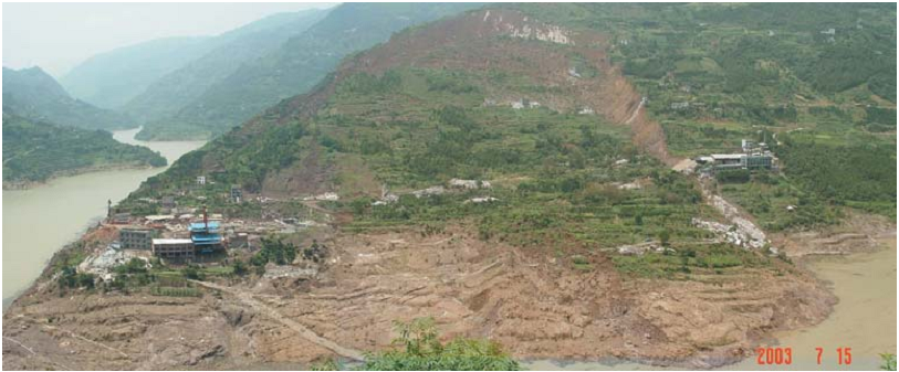
Qianjiangping landslide
LCI : CHN1607131433| Main Information | |
| Landslide Name | : Qianjiangping landslide |
| Latitude | : 30:57:25 N |
| Longitude | : 110:36:56 E |
| Location | |
| City / District | : Shazhenxi |
| Province | : Hubei |
| Country | : China |
| Reporter | |
| Reporter 1 | : Khang Dang |
| Reporter 2 | : Fa-Wu Wang |
| Landslide Type | |
| Material | : Complex |
| Movement | : Slide |
| Velocity (mm/sec) | : Rapid |
| Depth (m) | : Deep-Moderate |
| Slope (degree) | : Steep |
| Volume (m³) | : Very Large |
| Date of Occurence | |
| Date of Occurence | : Jul 14, 2003 |
| Other Information | |
| Land Use |
Source area : Wildland, Road Run-out/deposition area : River |
| Other Activity | : Active in the past |
| Triggering Factor | : Others |
| Death(s) & Missing | : 24 |
| Houses and other structural damage | : 346 houses and 70 ha of fields and rice paddy |
| Photo of landslide | :  |
| Google earth kmz file | : Qianjiangping landslide.kmz |
| Plan of landslide | : - |
| Cross section of landslide | :  |
| Reference (paper/report) | : http://link.springer.com/article/10.1007/s10346-004-0020-6 |
| Testing graph | : - |
| Monitoring graph | : Monitored Precipitation Data.JPG |
| Video of moving landslides including 3D simulation | : - |
| Description | : |
The Three Gorges Dam construction on the Yangtze River in China is the largest hydro-electricity project in the World. The first impoundment started from 95 m on June 1st, 2003, and reached 135 m on June 15th, 2003. Shortly after the water reached 135 m, many slopes began to de-form and some landslides occurred. In the early morning, at 00:20 July 14, 2003, the Qianjiangping landslide occurred at Shazhenxi Town beside Qinggan-he River, a tributary of the Yangtze. The Qianjiangping landslide was located on the western side of Qinggan-he River. On the opposite side of the river is the main street of Shazhenxi. The distance from the landslide to the junction of the Qinggan-he River with the Yangtze is about 3 km, and the distance along the Yangtze River from the junction to the Three Gorges Dam is about 50 km (the direct distance is about 40 km). The landslide had a tongue-shaped plan, with a length of 1,200 m, and a width of 1,000 m. It moved about 250 m in the main sliding direction of S450E. The average thickness of the sliding mass was about 20 m, thinner in the upper part and thicker at the lower part. The total volume was estimated to be more than 20 million cubic meters. The elevation of the main scarp was 450 m, and the elevation of the Qinggan-he River water level was 135 m when the landslide occurred. The landslide release surface was along a bedding plane in the bedrock. Standing trees on the sliding mass in the middle of the landslide indicate that the angle of the sliding surface remained constant and no rotation occurred. The exposed sliding surface at the upper part was very planar, and sub-parallel to the sandstone bedrock strata. All of these phenomena show that the sliding mass slid along a planar sliding surface. When the sliding mass entered Qinggan-he River, the dip direction of the strata was changed to N450W, which is opposite to the original dip direction of S450E. The dip angle is about 50 in the bed of Qinggan-he River. The deposits at the distal landslide margin contain white gravel with clasts up to 100mm-or-so in diameter. The dip angle of the sandstone bedding at the distal margin is steeper than 300. There was some loss of life and serious economic damage caused by the Qianjiangping landslide. It destroyed 346 houses and 70 ha of fields and rice paddy. Four factories on the lower part of the slope near Qinggan-he River were seriously damaged. Direct economic losses were about 7 million USD, and it reduced the asset value at Qianjiangping by 40%. In addition, 3 km of provincial roads and 20.5 km of electricity lines were cut. Twenty-two boats and ships were damaged and sunk in Qinggan-he River and the Yangtze River. Although a warning was given by the local government based on precursory deformation of the slope two hours before the final failure, 13 people on the slope, and 11 fishermen on boats in the nearby area were killed. The main reason for the deaths on the slope was that the people did not imagine that the landslide area would be so large, and believed their houses would be safe, because there was no ground defor-mation around them before the final failure of the slope. For the deaths on the river, the reason was just that it was not predicted that the landslide could move so rapidly. It was the wave caused by the rapid sliding that killed the fishermen on their boats. A water trace left on the red bridge detected after the landslide, indicated that the highest level of the wave was about 30 m above the water level of 135 m. This report referred the research in the paper: Fa-Wu Wang · Ye-Ming Zhang · Zhi-Tao Huo · Tatsunori Matsumoto · Bo-Lin Huang (2004) The July 14, 2003 Qianjiangping landslide, Three Gorges Reservoir, China. Landslides Vol. 1:157–162 |
|


