Ponzano landslide
LCI : ITA1810071110| Main Information | |
| Landslide Name | : Ponzano landslide |
| Latitude | : 42:46:30 N |
| Longitude | : 13:42:25 E |
| Location | |
| City / District | : Civitella del Tronto |
| Province | : Teramo |
| Country | : Italy |
| Reporter | |
| Reporter 1 | : Lorenzo Solari |
| Reporter 2 | : |
| Landslide Type | |
| Material | : Earth |
| Movement | : Complex |
| Velocity (mm/sec) | : Moderate |
| Depth (m) | : Moderate-Shallow |
| Slope (degree) | : Very gentle |
| Volume (m³) | : Large |
| Date of Occurence | |
| Date of Occurence | : Feb 12, 2017 |
| Other Information | |
| Land Use |
Source area : Pasture, Human settlement, Road Run-out/deposition area : Farming, Pasture |
| Other Activity | : Currently active |
| Triggering Factor | : Rainfall |
| Death(s) & Missing | : No deaths and missing |
| Houses and other structural damage | : 32 houses seriously damaged, 100 evacuees |
| Photo of landslide | : 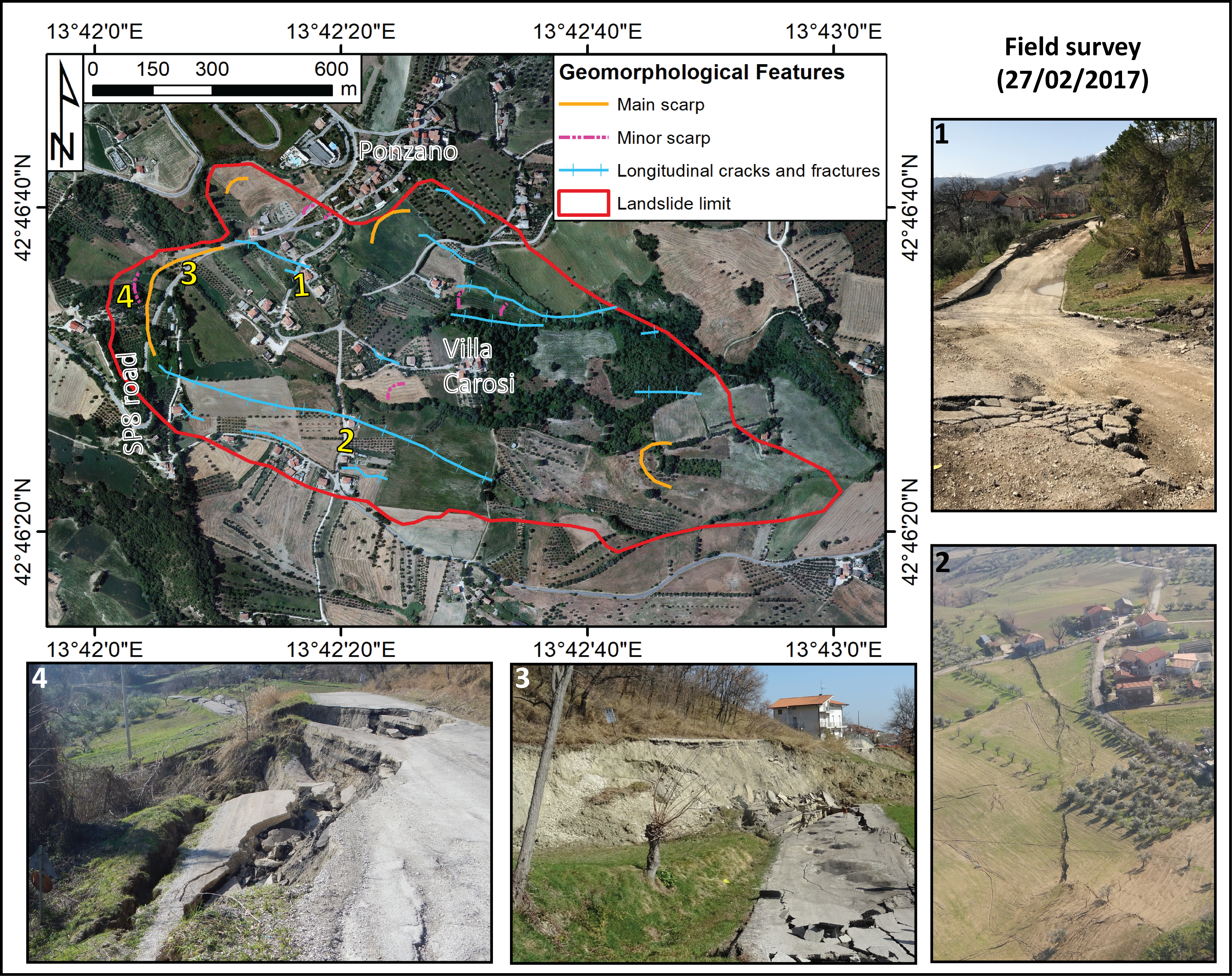 |
| Google earth kmz file | : landslide.kmz |
| Plan of landslide | :  |
| Cross section of landslide | : - |
| Reference (paper/report) | : Solari, L., Raspini, F., Del Soldato, M., Bianchini, S., Ciampalini, A., Ferrigno, F., Tucci, S. & Casagli, N. (2018). Satellite radar data for back-analyzing a landslide event: the Ponzano (Central Italy) case study. Landslides, 15(4), 773-782. doi:10.1007/s10346-018-0952-x (https://link.springer.com/article/10.1007/s10346-018-0952-x) |
| Testing graph | : Testing graph1538906062.tif |
| Monitoring graph | : Monitoring graph.tif |
| Video of moving landslides including 3D simulation | : - |
| Description | : |
On 12th February 2017, a landslide involved an area of around 60 ha on the SE facing slope of the Ponzano village (Civitella del Tronto municipality, Teramo Province, Abruzzi Region, Central Italy). The landslide, with an estimated volume of about 7000000 cubic meters, was triggered by the combination of two factors: i) saturation of the slope after the direct and slow infiltration of water related to the snow melting due to the increase of temperature between the end of January 2017 and the beginning of February 2017; ii) intense rainfalls recorded, between 6th and 10th February 2017 with a cumulative value of 81 mm, representing the 93% of the total rainfall of February 2017. The landslide is a complex movement in which two major components can be recognized: (i) rotational sliding affecting the upper and crown portion; (ii) an earth flow-like geometry in the central and toe portion of the landslide, characterized by a rupture surface estimated 15 m below the ground level. The landslide failure of February 2017 produced maximum displacements of about 10 m in some sectors of the affected area. The SqueeSAR algorithm was applied to two C-band SAR datasets, composed by Radarsat-2 and Sentinel-1 images, spanning a nine-year time interval before the landslide occurrence. Moreover, the amplitude information carried by two TerraSAR-X images, acquired immediately before and after the event, was exploited to derive the total displacement generated by the landslide movement by means of the RMT (Rapid Motion Tracking) algorithm. The obtained results allowed describing the landslide behavior before and after its failure. In particular, the back-monitoring analysis showed that the landslide was already slowly moving, with deformation rates increasing from the Radarsat-2 to the Sentinel-1 monitored periods, 10 years before its complete mobilization. Reference paper: https://link.springer.com/article/10.1007/s10346-018-0952-x |
|

