Kuridaira Landslide Dam
LCI : JPN169151630| Main Information | |
| Landslide Name | : Kuridaira Landslide Dam |
| Latitude | : 34:4:33.51 N |
| Longitude | : 135:50:7.92 E |
| Location | |
| City / District | : Nara |
| Province | : Nara |
| Country | : Japan |
| Reporter | |
| Reporter 1 | : Pham Tien |
| Reporter 2 | : |
| Landslide Type | |
| Material | : Rock, Debris, Earth |
| Movement | : Slide |
| Velocity (mm/sec) | : Extremely Rapid |
| Depth (m) | : Very Deep |
| Slope (degree) | : Steep |
| Volume (m³) | : Very Large |
| Date of Occurence | |
| Date of Occurence | : Sep 03, 2011 |
| Other Information | |
| Land Use |
Source area : Forest Run-out/deposition area : River |
| Other Activity | : Active in the past |
| Triggering Factor | : Rainfall |
| Death(s) & Missing | : - |
| Houses and other structural damage | : - |
| Photo of landslide | : 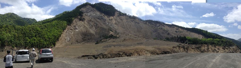 |
| Google earth kmz file | : Kuridaira landslide.kmz |
| Plan of landslide | : .JPG) |
| Cross section of landslide | : 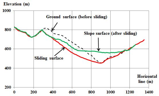 |
| Reference (paper/report) | : SABO (2013) A Pamphlet released in October, 2013 on overview of the 2011 disaster induced by Typhoon No. 12, Implementation of an urgent investigation and countermeasures to disaster areas. Kii Mountain District SABO Office, Kinki Regional Development Bureau. The Ministry of Land, Infrastructure, Transport and Tourism (MLIT). Available at http://www.kkr.mlit.go.jp/kiisanchi/outline/, 24 pages (in Japanese). |
| Testing graph | :  |
| Monitoring graph | : - |
| Video of moving landslides including 3D simulation | : - |
| Description | : |
On 3 September 2011, a large-scale deep-seated landslide was triggered by heavy rainfall produced by Typhoon Talas in the Kuridaira valley, Totsukawa village, Nara Prefecture, Japan. The landslide with 850 m in length, 600 m in width and a maximum depth of 120 m became the largest biggest landslide in the 2011 disaster. The collapsed sediment estimated to be 25 million m3. The sliding soil mass moved down and then blocked a river to form a natural landslide dam in a large basin area approximately 8.7 km2. The dam had a water storage capacity of 7.5 million cubic meters. |
|
.JPG)
.JPG)
.JPG)


.JPG)