MAIERATO LANDSLIDE
LCI : ITA1801121525| Main Information | |
| Landslide Name | : MAIERATO LANDSLIDE |
| Latitude | : 38:41:04 N |
| Longitude | : 16:11:07 E |
| Location | |
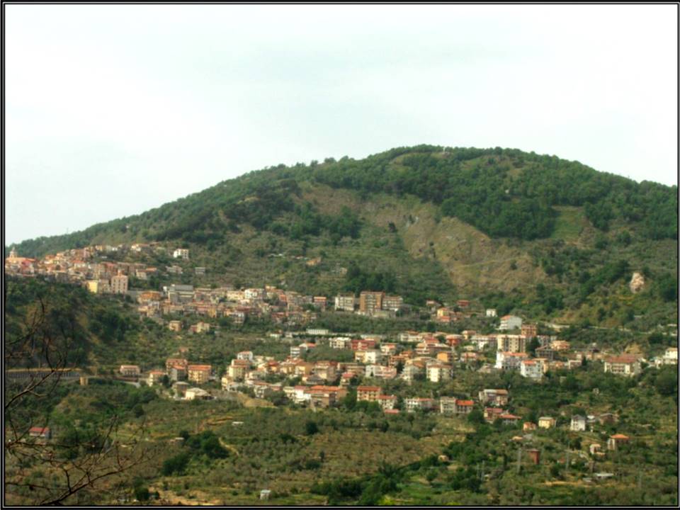
| City / District | : MAIERATO |
| Province | : VIBO VALENTIA |
| Country | : Italy |
| Reporter | |
| Reporter 1 | : GIOVANNA CAPPARELLI |
| Reporter 2 | : PASQUALE VERSACE |
| Landslide Type | |
| Material | : Rock, Debris |
| Movement | : Flow |
| Velocity (mm/sec) | : Very Rapid |
| Depth (m) | : Deep-Moderate |
| Slope (degree) | : Gentle |
| Volume (m³) | : Large |
| Date of Occurence | |
| Date of Occurence | : Feb 15, 2010 |
| Other Information | |
| Land Use |
Source area : Farming, Pasture, Urban area, Human settlement, Road Run-out/deposition area : Farming, Pasture, Urban area, Human settlement, Road |
| Other Activity | : Active in the past |
| Triggering Factor | : Human activity and rainfall |
| Death(s) & Missing | : NO |
| Houses and other structural damage | : YES |
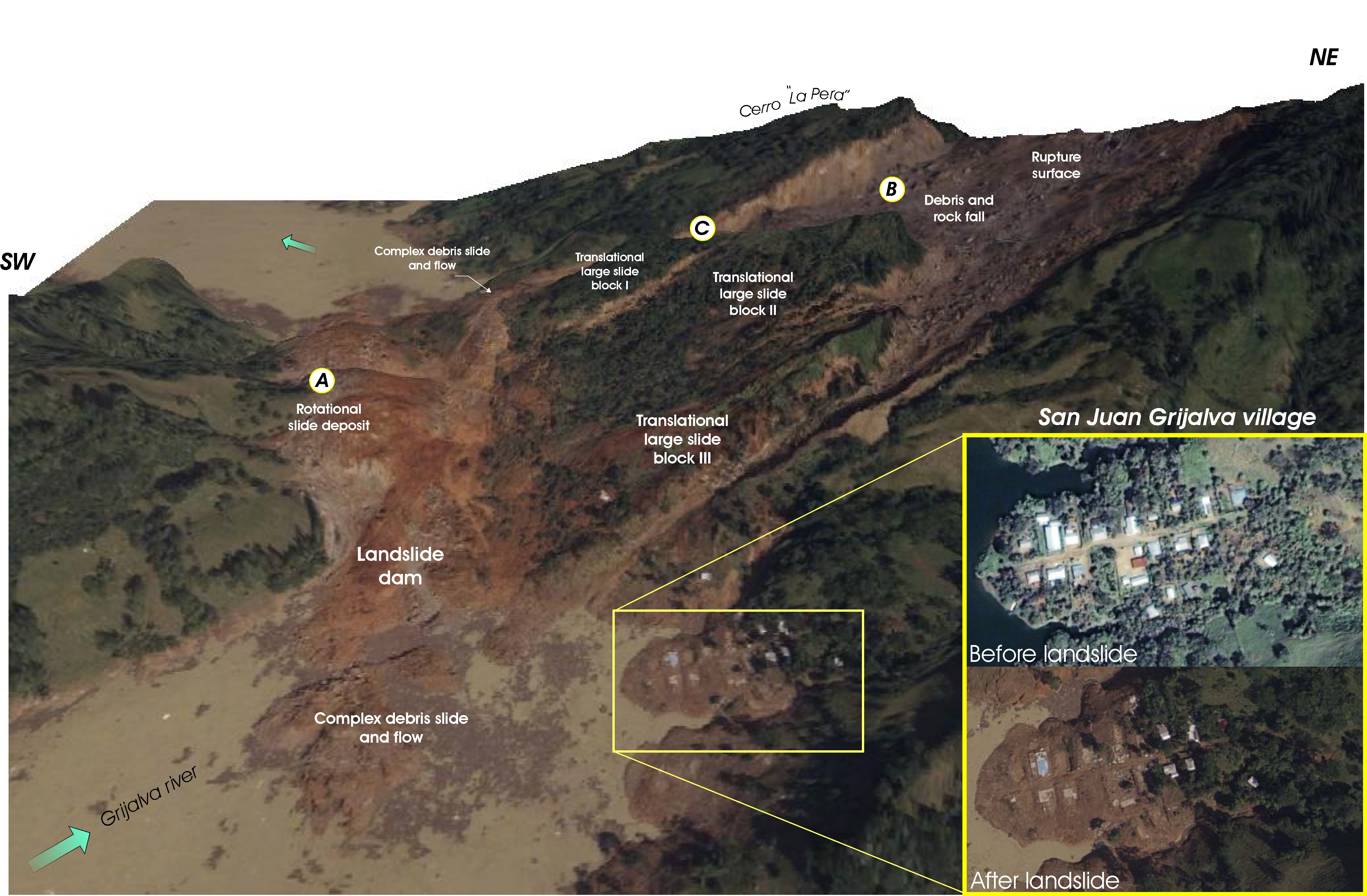
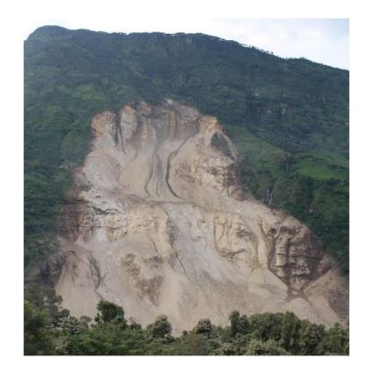
| Photo of landslide | : 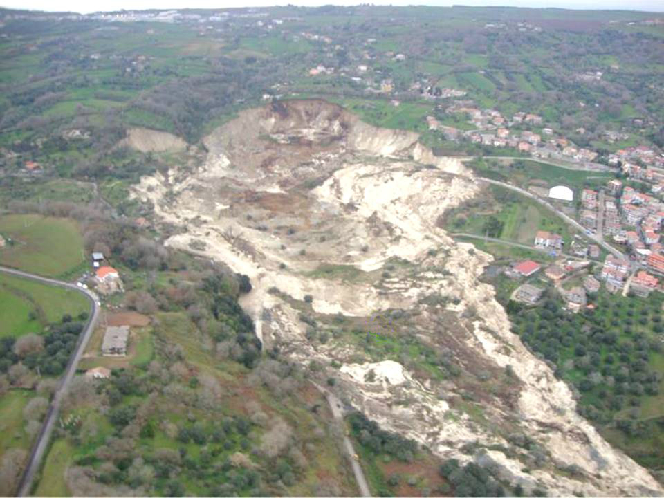 |
| Google earth kmz file | : Frana_Maierato_2010.kmz |
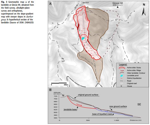
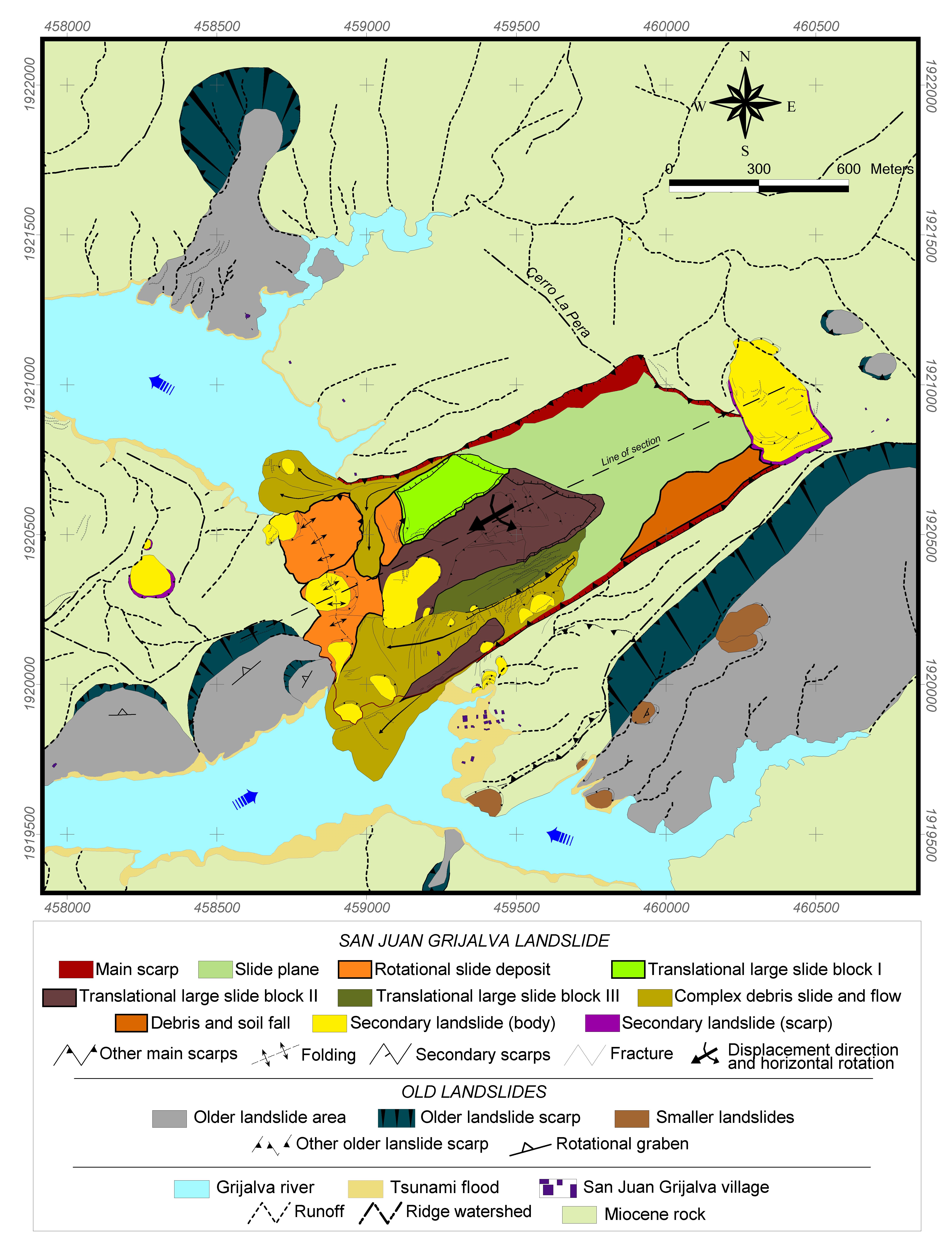
| Plan of landslide | :  |
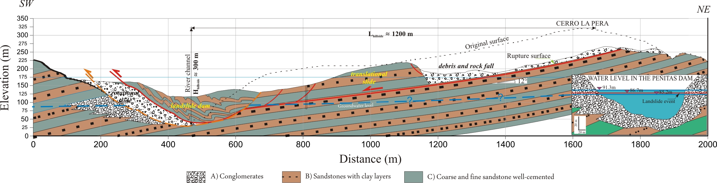
| Cross section of landslide | :  |
| Reference (paper/report) | : https://www.researchgate.net/publication/308015414_Kinematics_of_the_Maierato_Landslide_Calabria_Southern_Italy https://www.researchgate.net/publication/285948650_Geomatics_activities_for_monitoring_the_large_landslide_of_Maierato_Italy https://www.researchgate.net/publication/308792641_Esperienze_di_monitoraggio_topografico_di_grandi_frane_i_casi_di_Gimigliano_e_Maierato https://www.researchgate.net/publication/281111519_Analysis_of_the_rainfall_preceding_the_activation_of_the_large_Maierato_landslide_in_2010 http://www.cnr.it/istituti/Allegato_95848.pdf?LO=01000000d9c8b7a6090000000c0000002caf00006e679c53000000000100000000000000000000000000000000000000000000000000000000000000000000000000000000000000&type=application/pdf |
| Testing graph | : TESTING GRAPH.pdf |
| Monitoring graph | : - |
| Video of moving landslides including 3D simulation | : https://www.youtube.com/watch?v=mL4XBpEg97I |
| Description | : |
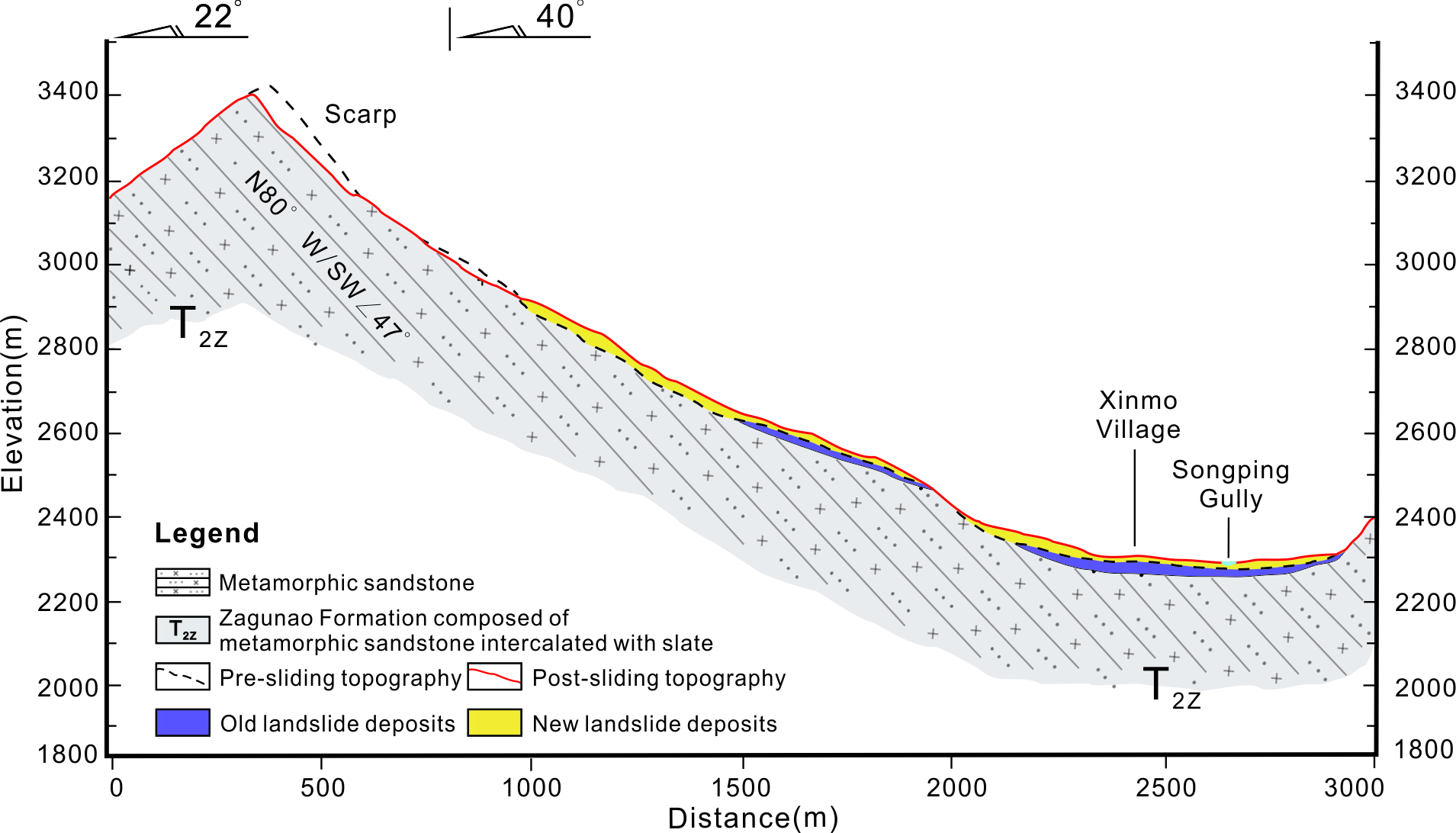
Maierato is located in Vibo Valentia’s territory, few kilometers from the Mar Tirreno in central Calabria. The Maierato’s town rises on a slope without particularly accentuated inclinations, but it is deeply disturbed by an enormous and ancient gravitational deformation (Guerricchio et Al., 2010). Moreover, the territory is characterized by ancient and “Great Lands”, these probably born as a result of marine regressions during glacial periods. In addition, the predisposition to landslide events was strongly characterized by the disastrous earthquake occurred in 1973, which generated fractures and considerable masses dislocated over the whole slope. As a consequence, the seep rains feed a powerful aquifer localized in the permeable layers of deposits. Due to the almost verticality of the cracks, the outflow occurs with a high gradient (about 10%) which, in case of abundant infiltrations, can generate a real “underground torrent”. The landslide of February 15th 2010 was preceded by a long phase of deformation that later produced the collapsed of slope. The elevation speed of the phenomenon seems to suggest that the movement has developed on a completely fluidized substrate, allowing to the ancient landslide debris to mobilize with great energy. The water level has generated pressures in order to cancel the effective stress, inducing a real liquefaction. The conditions favored a collapse in according to a mechanism of multiple rotational sliding, followed by a deep “disarticulation” of the landslide. It could be considered as a “debris flow with rock blocks”. The landslide movement has a main scarp with a development of approximately 1.1 km and with a maximum depth about 50 m. The average depth of the landslide body was estimated at 25-30 m, with a volume that exceeds 8 million m3. |
|


