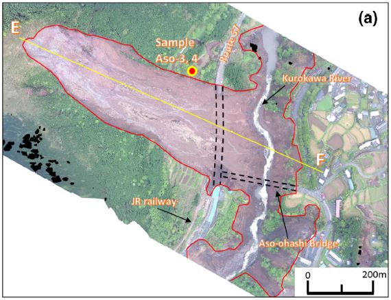
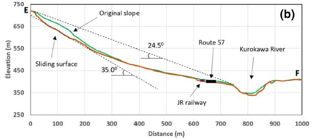
Sunkoshi landslide
LCI : NPL1612061032| Main Information | |
| Landslide Name | : Sunkoshi landslide |
| Latitude | : 27:46:14.64 N |
| Longitude | : 85:52:6.48 E |
| Location | |
| City / District | : Sindhupalchok |
| Province | : Sindhupalchok |
| Country | : Nepal |
| Reporter | |
| Reporter 1 | : Pham Tien |
| Reporter 2 | : |
| Landslide Type | |
| Material | : Rock, Complex |
| Movement | : Slide |
| Velocity (mm/sec) | : Extremely Rapid |
| Depth (m) | : Deep-Moderate |
| Slope (degree) | : - |
| Volume (m³) | : Large |
| Date of Occurence | |
| Date of Occurence | : Aug 02, 2014 |
| Other Information | |
| Land Use |
Source area : Forest, Human settlement Run-out/deposition area : Road, River |
| Other Activity | : Active in the past |
| Triggering Factor | : Rainfall |
| Death(s) & Missing | : 156 |
| Houses and other structural damage | : Sunkoshi hydropower dam , highway |
| Photo of landslide | : 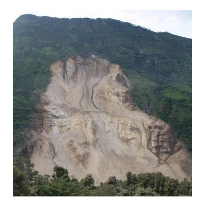 |
| Google earth kmz file | : Sunkoshi landslide.kmz |
| Plan of landslide | :  |
| Cross section of landslide | : - |
| Reference (paper/report) | : Report on Jure Landslide, Mankha VDC, Sindhupalchowk District, Nepal Government Ministry of Irrigation, August 24, 2014, 29 pages in English. Available at http://www.sabo-int.org/case/2014_aug_nepal.pdf and A report by DpNET. Available at http://dpnet.org.np/docs/reportManagement/c1177e6cb4970cf8b32f2a789a05d67c.pdf |
| Testing graph | : - |
| Monitoring graph | : - |
| Video of moving landslides including 3D simulation | : - |
| Description | : |
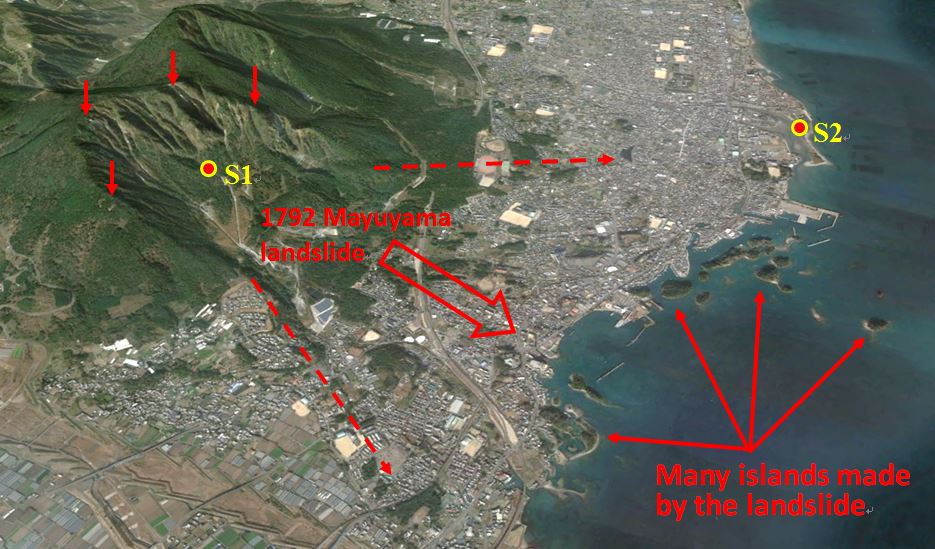
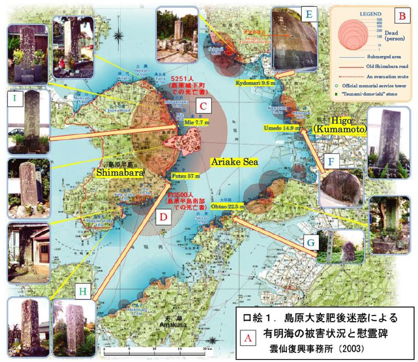
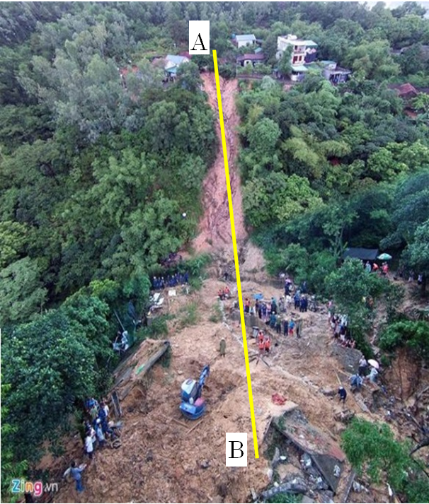
The Jure landslide or the Sunkoshi landslide, a deep-seated catastrophic landslide was triggered by a heavy rainfall at 02:36 AM on Saturday morning, 2 August 2014 in Jure Village, Sindhupalchowk District, Nepal. The huge landslide claimed 156 people, caused a seriously damages to tens of house. The landslide created a rapidly massive wave of about 100 meter towards the opposite bank of the river, which destroyed the forest area on the left bank of Sunkoshi River with a height of 100 m. The landslide velocity was estimated from 60 to 70m per second and it completely dammed the river within about 2 – 3 minutes. The catastrophic landslide also resulted in a local quake of 3.3 magnitudes. In addition, the large volume of debris about 7.4 million cubic meters blocked the Sunkoshi River and created a dam that is about 3 km long, 300 to 350 m width and 46.7 m depth. The deposited materials damaged the two gates of the Sunkoshi hydropower dam by the pressurized surging of the mud and debris. The outburst discharge and the dam breach took place on 7 September 2014. Sources: – Report on Jure Landslide, Mankha VDC, Sindhupalchowk District, Nepal Government Ministry of Irrigation, August 24, 2014, 29 pages in English. Available at http://www.sabo-int.org/case/2014_aug_nepal.pdf . – A report by Disaster Preparedness Network Nepal (DPNet Nepal). Available at http://dpnet.org.np/docs/reportManagement/c1177e6cb4970cf8b32f2a789a05d67c.pdf |
|

1480694486.jpg)

