Nikawa landslide
LCI : JPN1607131731| Main Information | |
| Landslide Name | : Nikawa landslide |
| Latitude | : 34:46:25 N |
| Longitude | : 135:20:23 E |
| Location | |
| City / District | : Nishinomiya |
| Province | : Hyogo |
| Country | : Japan |
| Reporter | |
| Reporter 1 | : Khang Dang |
| Reporter 2 | : Kyoji Sassa |
| Landslide Type | |
| Material | : Earth |
| Movement | : Slide |
| Velocity (mm/sec) | : Rapid |
| Depth (m) | : Deep-Moderate |
| Slope (degree) | : Moderate |
| Volume (m³) | : Large-Moderate |
| Date of Occurence | |
| Date of Occurence | : Jan 17, 1995 |
| Other Information | |
| Land Use |
Source area : Forest Run-out/deposition area : Urban area |
| Other Activity | : Active in the past |
| Triggering Factor | : Earthquake |
| Death(s) & Missing | : 34 |
| Houses and other structural damage | : - |
| Photo of landslide | : 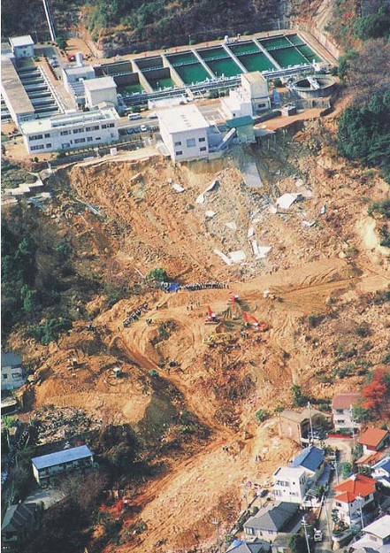 |
| Google earth kmz file | : Nikawa landslide.kmz |
| Plan of landslide | : 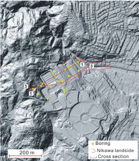 |
| Cross section of landslide | : 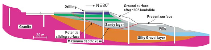 |
| Reference (paper/report) | : https://www.jstage.jst.go.jp/article/sandf1995/40/1/40_1_35/_article |
| Testing graph | : Testing Graphs-Nikawa.docx |
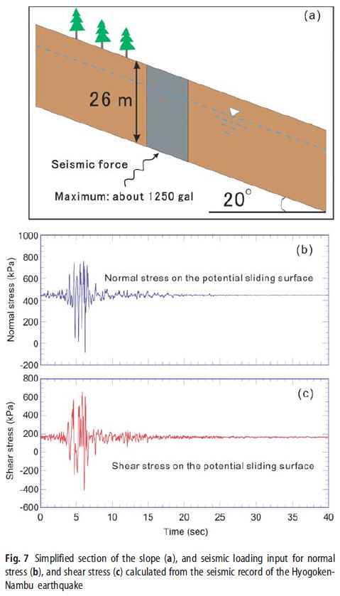
| Monitoring graph | : Seismic Record.JPG |
| Video of moving landslides including 3D simulation | : - |
| Description | : |
The Nikawa landslide (34 fatalities) was triggered by the 1995 Hyogoken-Nambu earthquake in Nishinomiya city between Osaka and Kobe. Drilling investigations (including boreholes drilled immediately after the earthquake and new ones drilled during this investigation) revealed that the bedrock is granite, which is overlain by Quaternary marine and lacustrine deposits (the Osaka group formation). The Osaka group formation consists of a silty gravel layer, a sandy layer interbedded with some clayey layers above it, overlain by fills. Note that the matrix of the silty gravel layer is mainly composed of fine sand and silt characterized by a very low permeability. The overall permeability of the silty gravel layer obtained through in-situ tests is about 10-7 m/s, while that of the sandy layer above it is 10-6 m/s. During an earthquake, a potential sliding surface is inferred to develop through the interface be-tween the sandy layer and the silty gravel layer where its shape, scale and inclination is very similar to the rupture surface of the Nikawa landslide. The maximum depth of the potential sliding surface is 26 m, and it has an average angle of about 20 degrees. The groundwater level in the section where the slip surface is 26 m deep is 16 m above the slip surface. Source: Sassa, K., Wang, G., Fukuoka, H. et al. Landslide risk evaluation and hazard zoning for rapid and long-travel landslides in urban development areas. Landslides (2004) 1: 221. doi:10.1007/s10346-004-0028-y |
|

