Muriwai landslide
LCI : LCI_AKL2| Main Information | |
| Landslide Name | : Muriwai landslide |
| Latitude | : 34:49:18.71 S |
| Longitude | : 174:26:28.03 E |
| Location | |
| City / District | : Muriwai |
| Province | : Auckland |
| Country | : New Zealand |
| Reporter | |
| Reporter 1 | : Martin Brook |
| Reporter 2 | : |
| Landslide Type | |
| Material | : Complex |
| Movement | : Complex |
| Velocity (mm/sec) | : Extremely Rapid |
| Depth (m) | : Shallow |
| Slope (degree) | : Steep |
| Volume (m³) | : Moderate-Small |
| Date of Occurence | |
| Date of Occurence | : Feb 13, 2023 |
| Other Information | |
| Land Use |
Source area : Human settlement Run-out/deposition area : Human settlement |
| Other Activity | : Unknown |
| Triggering Factor | : Rainfall |
| Death(s) & Missing | : 2 |
| Houses and other structural damage | : 5 |
| Photo of landslide | : - |
| Google earth kmz file | : Muriwai landslide.kmz |
| Plan of landslide | : 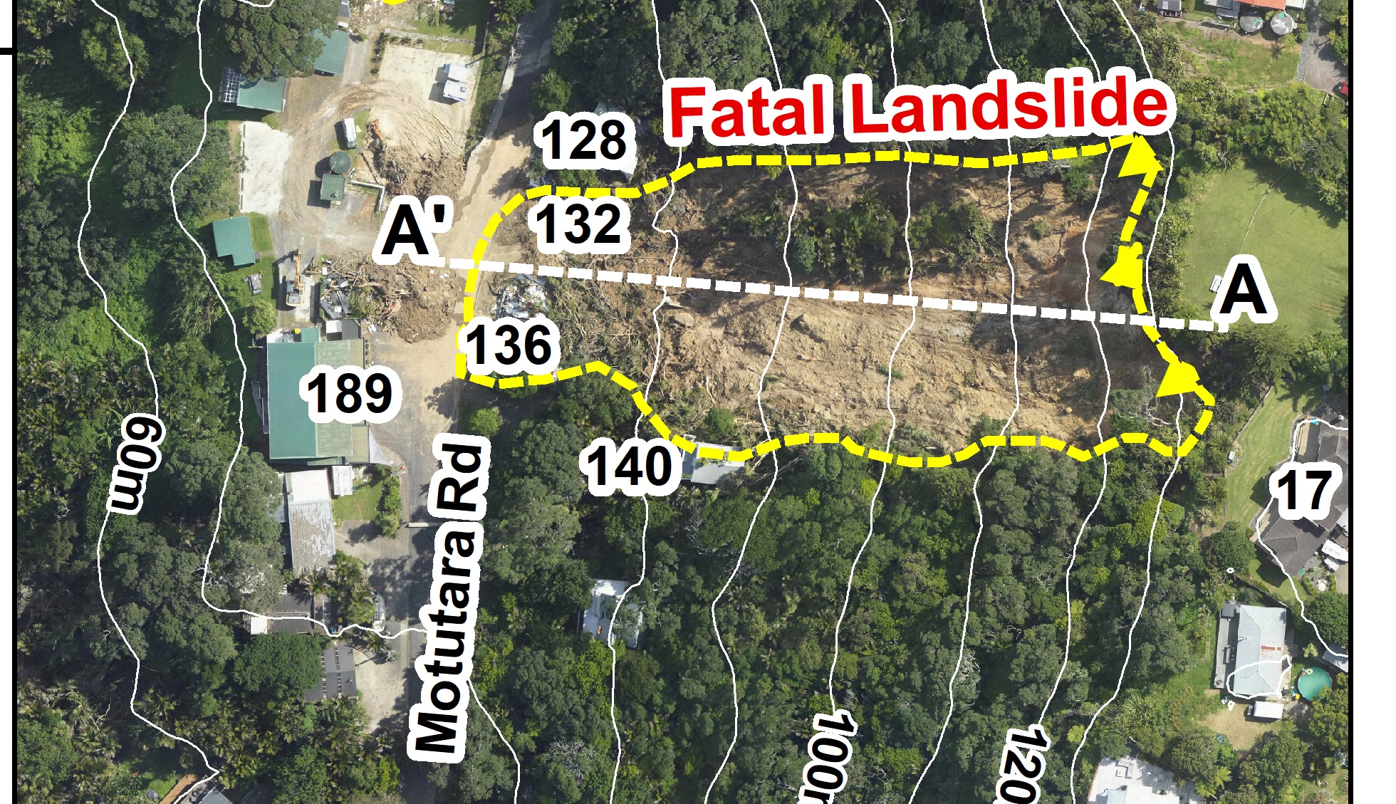 |
| Cross section of landslide | : 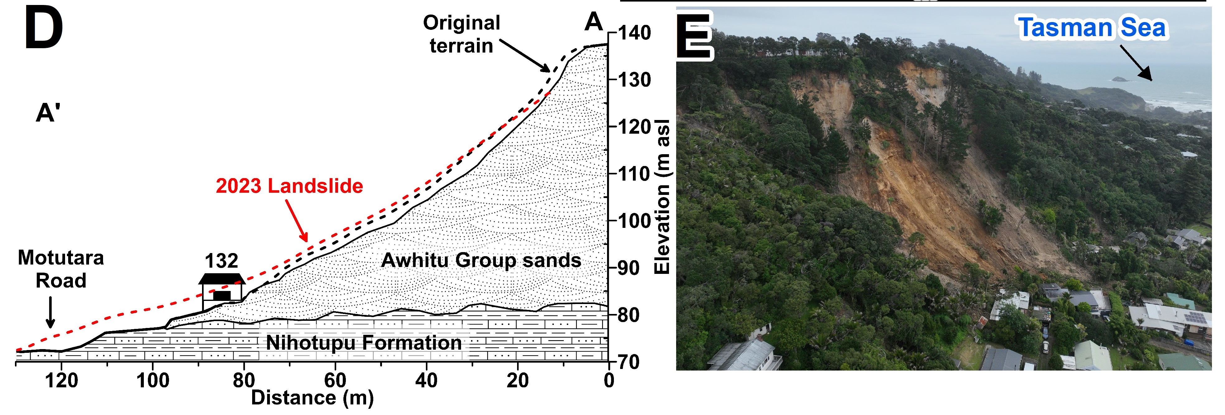 |
| Reference (paper/report) | : Brook, M.S., Nicoll, C. Brief report of fatal rainfall-triggered landslides from record-breaking 2023 storms in Auckland, New Zealand. Landslides 21, 1581–1589 (2024). https://doi.org/10.1007/s10346-024-02258-0 |
| Testing graph | : - |
| Monitoring graph | : - |
| Video of moving landslides including 3D simulation | : - |
| Description | : |
With January 2023 Auckland’s wettest January on record, and with the region still in a state of emergency, Tropical Cyclone Gabrielle crossed the region on February 13–14. This caused widespread landsliding, including a fatal landslide at Muriwai on the west Auckland coast. Fatal landslides from the same escarpment had occurred in 1965, close to the February 13, 2023, fatal landslide. The tragic deaths of the two firefighters occurred during inspection of a house on Motutara Road around 10 pm on February 13. Muriwai is an interesting location because much of the town lies below a ~80-m high escarpment formed within soft, Pleistocene Awhitu Group sands. These are poorly-cemented dune sands and silts. In situ, the Awhitu Group sands have a tendency to dilate when wetted but are firm to stiff (Su ~100 kPa) and can sustain steep (~40°) slopes in drained conditions. However, the crenulated ridgeline immediately west of Oaia Road indicates that several landslides have occurred in the past along the escarpment above the town. Indeed, in August 1965, 2 fatal landslides occurred on consecutive days at Domain Crescent, in the form of slides that transitioned to rapid (90 km/h) flows, which inundated houses, following substantial (220 mm) rainfall (Wright 1966). While landslides from TC Gabrielle did inundate the Domain Crescent houses that were rebuilt after the 1965 fatal landslides, Domain Crescent was evacuated during TC Gabrielle on February 13 at 9–10 pm. At Motutara Road in 2023, as with Domain Crescent in 1965, the Awhitu Group sands unconformably overly the relatively impermeable Nihotupu Formation volcaniclastic sediments of the Miocene Waitakere Group. Groundwater tends to flow downwards through the permeable Awhitu Group dune sands, until it reaches the erosional contact with the underlying Waitakere Group Nihotupu Formation, which acts as an aquiclude, increasing porewater pressure within the overlying Awhitu Group. During the passage of TC Gabrielle, landslides in the Awhitu Group occurred at several places along the escarpment, inundating houses below, but the fatalities were limited to 132–136 Motutara Road. The landslide there was initiated in the slope above the evacuated house at ~130 m asl (Fahrböschung angle = 26°), which inundated the house, while firefighters were digging a trench to divert floodwater. The inundated house was transported by the landslide into the roadway below, while further landslides occurred nearby. One firefighter died at the scene, while a second (rescued) firefighter died in hospital on February 16. |
|

