Lang Nu
LCI : VNM20250830| Main Information | |
| Landslide Name | : Lang Nu |
| Latitude | : 22:7:12.85 N |
| Longitude | : 104:31:39.85 E |
| Location | |
| City / District | : Bao Yen |
| Province | : Lao Cai |
| Country | : Việt Nam |
| Reporter | |
| Reporter 1 | : Pham Tien |
| Reporter 2 | : Van Tien Pham |
| Landslide Type | |
| Material | : Rock, Debris |
| Movement | : Slide, Flow |
| Velocity (mm/sec) | : Extremely Rapid |
| Depth (m) | : Deep-Moderate |
| Slope (degree) | : Moderate |
| Volume (m³) | : Large |
| Date of Occurence | |
| Date of Occurence | : Sep 10, 2024 |
| Other Information | |
| Land Use |
Source area : Forest Run-out/deposition area : Human settlement |
| Other Activity | : Currently active |
| Triggering Factor | : Rainfall |
| Death(s) & Missing | : 67 |
| Houses and other structural damage | : 40 |
| Photo of landslide | : - |
| Google earth kmz file | : Lang Nu landslide.kmz |
| Plan of landslide | : - |
| Cross section of landslide | : 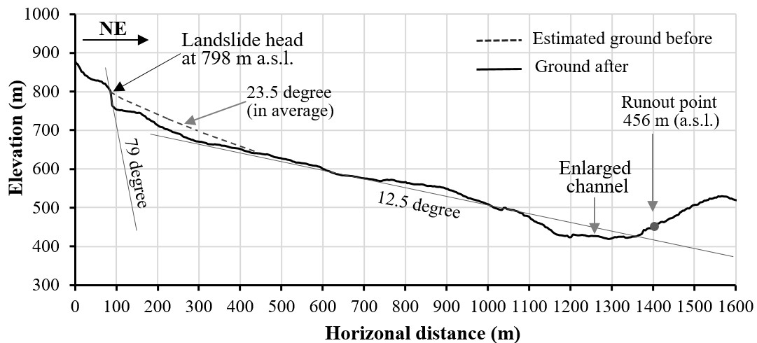 |
| Reference (paper/report) | : https://link.springer.com/article/10.1007/s10346-025-02490-2 |
| Testing graph | : - |
| Monitoring graph | : - |
| Video of moving landslides including 3D simulation | : - |
| Description | : |
At around 5:55 AM (local time, GMT+7) on 10 September 2024, a rapid, long-runout landslide induced by prolonged heavy rainfall struck Lang Nu hamlet, Phuc Khanh commune, Bao Yen district, Lao Cai province, Vietnam, resulting in 67 fatalities. The analysis results show that the Lang Nu event was a large-scale rockslide on the slope of Con Voi Mountain, involving an estimated volume of approximately 1.1 million cubic meters. The failure developed along foliation and fault planes dipping northeast, following the dip direction of the strata. The foliated, fractured, and sheared schistose rock mass acted as the primary preparatory condition for slope instability. The immediate triggering factor was the extreme rainfall event, with a cumulative total of 356.6 mm over 55 hours. Under the local geological setting of the source area, groundwater rise and hydrostatic pressure buildup during intense rainfall likely drove the slope failure. The calculated reach angle of 11.6° reflects the high mobility of the landslide, which caused rapid, long-distance movement and catastrophic destruction. Importantly, no field evidence suggested the formation of landslide-dammed lakes that might have generated secondary hazards such as dam breach and outburst flooding in Lang Nu hamlet. The Lang Nu landslide was the deadliest landslide disaster in Vietnam’s recent history and may be regarded as the most catastrophic natural landslide ever recorded in the country, leaving the entire nation in shock. |
|

