Aso-ohashi landslide
LCI : JPN1609160915| Main Information | |
| Landslide Name | : Aso-ohashi landslide |
| Latitude | : 32:53:9.42 N |
| Longitude | : 130:59:2.72 E |
| Location | |
| City / District | : Mimami-Aso |
| Province | : Kumamoto |
| Country | : Japan |
| Reporter | |
| Reporter 1 | : Khang Dang |
| Reporter 2 | : Kyoji Sassa |
| Landslide Type | |
| Material | : Earth |
| Movement | : Slide |
| Velocity (mm/sec) | : Extremely Rapid |
| Depth (m) | : Deep-Moderate |
| Slope (degree) | : Moderate |
| Volume (m³) | : Large |
| Date of Occurence | |
| Date of Occurence | : Apr 16, 2016 |
| Other Information | |
| Land Use |
Source area : Forest, Road, Railways Run-out/deposition area : Road, Railways, River |
| Other Activity | : Active in the past |
| Triggering Factor | : Earthquake |
| Death(s) & Missing | : 1 |
| Houses and other structural damage | : One bridge, road and railway line |
| Photo of landslide | : 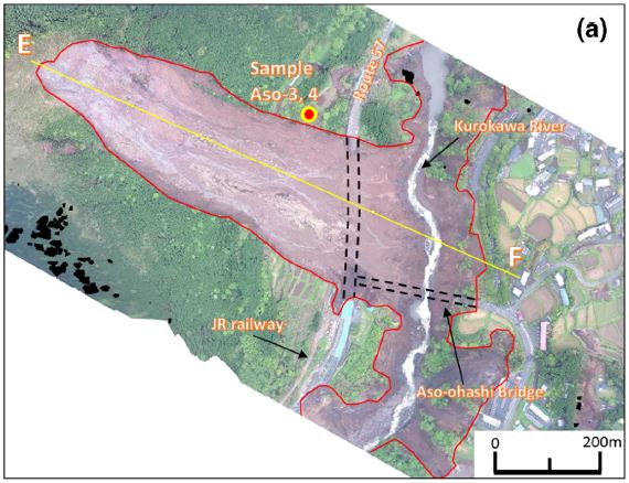 |
| Google earth kmz file | : Aso-ohashi Landslide.kmz |
| Plan of landslide | : |
| Cross section of landslide | : 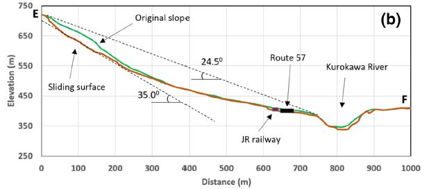 |
| Reference (paper/report) | : http://link.springer.com/article/10.1007/s10346-016-0748-9 |
| Testing graph | : Kumamoto Testing Data with graph-Seismic1478768056.xlsx |
| Monitoring graph | : Kumamoto Earthquake Graph-Final1478768056.xlsx |
| Video of moving landslides including 3D simulation | : https://youtu.be/y-wh0RBfKWU |
| Description | : |
The Aso-ohashi landslide is situated at the western tip of the caldera of Mount Aso. It was named after the 200-m long Aso-ohashi bridge that formerly spanned the 80-m deep gorge of the Kurokawa River before it was destroyed by the landslide on April 16 during the magnitude 7.3 earthquake. This area is characterized by soft ground composed of weathered volcanic cohesive soil (Geological map display system of Geological Survey of Japan, AIST, 2016). The average slope angle of the sliding surface was 35.0 degrees and the average apparent friction angle was about 24.5 degrees. The maximum depth was measured as approximately 35 m. The landslide mass traveled a distance of about 800 m, deposited much debris onto National Route 57, and severely damaged a section of the JR Hohi railway track running parallel to the highway (The Japan Time 2016). This landslide also destroyed an important bridge connecting Minamiaso village to the city of Kumamoto. – – – – – Source: Dang, K., Sassa, K., Fukuoka, H. et al. “Mechanism of two rapid and long-runout landslides in the 16 April 2016 Kumamoto earthquake using a ring-shear apparatus and computer simulation (LS-RAPID)”. Landslides (2016). doi:10.1007/s10346-016-0748-9 |
|

