Aranayaka Landslide
LCI : LKA201911261713| Main Information | |
| Landslide Name | : Aranayaka Landslide |
| Latitude | : 7:9:19.22 N |
| Longitude | : 80:25:50.06 E |
| Location | |
| City / District | : Kegalle |
| Province | : Sabaragamuwa |
| Country | : Sri Lanka |
| Reporter | |
| Reporter 1 | : Khang Dang |
| Reporter 2 | : |
| Landslide Type | |
| Material | : Rock, Earth |
| Movement | : Complex |
| Velocity (mm/sec) | : Extremely Rapid |
| Depth (m) | : Deep-Moderate |
| Slope (degree) | : Steep |
| Volume (m³) | : Large |
| Date of Occurence | |
| Date of Occurence | : May 17, 2016 |
| Other Information | |
| Land Use |
Source area : Forest, Farming Run-out/deposition area : Human settlement, Road |
| Other Activity | : Active in the past |
| Triggering Factor | : Rainfall |
| Death(s) & Missing | : 127 |
| Houses and other structural damage | : 75 houses |
| Photo of landslide | :  |
| Google earth kmz file | : Aranayake Landslide.kmz |
| Plan of landslide | :  |
| Cross section of landslide | :  |
| Reference (paper/report) | : https://link.springer.com/article/10.1007/s10346-018-1089-7 |
| Testing graph | :  |
| Monitoring graph | : 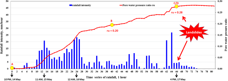 |
| Video of moving landslides including 3D simulation | : - |
| Description | : |
A rapid and long-traveling landslide was triggered at Aranayaka, Kegalle district, Sri Lanka on 17 May 2016 by exceptionally heavy rainfall associated with a slow-moving tropical cyclone. The precipitation that accumulated within the last 3 days from May 14 to 17 reached 446.5 mm. The landslide mass traveled over an approximately 2-km distance killing 127 people and destroying 75 houses. To deduce the failure mechanism of the Aranayaka landslide, shear behavior of two samples taken from the initial landslide area were examined through ring-shear tests. The first sample (S1) was taken from the weathered soil layer on the left scarp of the landslide. The second sample (S2) was taken from the weathered granitic gneiss at the bottom of the depression in the middle part of the landslide area. The layer was affected by intense tectonic crushing and subsequent deep weathering. A high value of shear resistance at steady state was measured on the sample S1 while the sample S2 obtained a much smaller steady state shear resistance. This indicated that the sliding surface of the landslide was located in the weathered granitic gneiss associated with the sample S2. A series of computer simulations of this landslide was then carried out given the soil parameters from the ring-shear tests and pore-water pressure ratio estimated from the rainfall records using the “SLIDE” model. In the simulation, the landslide initiated from the middle part of the source area, close to the location from where sample S2 was taken. Moreover, the time of occurrence from the simulation was similar to that observed in the real event. This is a very important information to assess further rapid landslides in areas with similar conditions. This study also indicates the importance of selecting soil samples and suggests that the ring-shear apparatus and computer simulations are effective tools to reproduce the process of landslides. |
|

