Main Information
LCI: PHL169151720
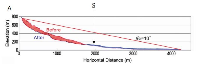
At 10:30 on February 17, 2006, a massive rock slide-debris avalanche was triggered by combined earthquakes-rainfalls impacts in the Southern Leyte Province, Philippine. The landslide with its volume about 20 million cubic meters occurred after 10-day period of heavy rainfalls and a minor earthquake (M 2.6). The rapid and long travelling movement mass buried Guinsaugon village in the town of Saint Bernard. As a result, the catastrophic disaster caused widespread damages to socio-economic infrastructures and claimed 1,126 people. This is the worst disaster hit Guinsaugon community. The collapsed slope has geologic features of weathered volcano-clastic rocks. The landslide mass moved from the slope and deposited on the flat area with a length about 4 km. Source: Kyoji Sassa, Osamu Nagai, Renato Solidum, Yoichi Yamazaki, Hidemasa Ohta (2010) “An integrated model simulating the initiation and motion of earthquake and rain induced rapid landslides and its application to the 2006 Leyte landslide”, Landslides Vol.7, pp:219-236.
Location
City / District: Guinsaugon
Province: Leyte
Country: Philippines
Latitude: 10:20:0 N
Longitude: 125:5:50 E
Reporter
Reporter 1: Pham Tien
Reporter 2: Kyoji Sassa
Landslide Type
Material: Complex
Movement: Slide
Velocity (mm/sec): Very Rapid (5×10¹ - 5×10³)
Depth (m): Very Deep (100 - 500)
Slope (degree): Moderate (20 - 30)
Volume (m³): Very Large (10⁷-10⁸)
Date of Occurence
Date of Occurence: 02/17/2006
Other Information
Land use (Source Area): Forest
Land use (Run-out/deposition area): River
-
-
Death(s) & Missing: -
Houses and other structural damage: -
Photo of landslide
Google earth kmz file
Plan of landslide
Cross section of landslide